
I’m a frequent user of Google Earth to help enrich my presentations in front of large and demanding audiences. When introducing a new and exotic location, I find nothing beats an attractive and useful map or satellite image.
Google Earth is an invaluable tool for providing your audiences with geographic context and added interest in your presentations. Google has added a lot of tools and enhancements over the past few months to make it even easier to add content. Here’s a quick overview.
How many times have you watched a travel video wishing they’d included a map to provide some idea of location? — especially in these days of exploding numbers of YouTube travel vloggers!
Well, there really is no excuse as far as I’m concerned, now that these excellent tools are so readily available. (BTW, Google Earth provides tools that we could have only dreamed of when I first started giving slide presentations – back then a dissolve unit between two slide projectors was a BIG deal!)
How Can You Provide Geographic Context in Presentations?
Television news studios have been doing this for ages, and now you have the tools to do it yourself. What do I mean?
How many times have you seen a news story where the camera appears to zoom towards a particular location on earth as an intro shot? In the old days, this would have been nearly impossible for an individual at home with their own computer.
Of course, Google Earth has changed all that.
Here’s a quick example of the type of geographic context I like to provide in my own travel videos.
Google Earth provides Excellent Tutorial Videos
Introducing satellite fly-overs in your presentations can be daunting at first. Once you begin to experiment with the tools available, I think you’ll begin to see that it is time well spent. I would say that you could produce your first Google Earth fly over in a couple of hours.
It took me days of experimenting when I first began to use Google Earth Pro, but I didn’t have the benefit of the excellent video tutorials that Google provides today.
Google Earth Tutorial: Intro to Creation Tools
Here’s a short tutorial intro to an excellent series of videos on a simple approach to incorporating satellite images into your own presentations:
In my work, I frequently use Google Earth Pro to produce video flyovers. I really enjoy the fact that I can zoom into any location on earth and, if the resolution of the image is good enough, I can take my audience on a quick tour by following a particular geographic feature such as a shoreline or river, circling a mountain peak, or hopping from one island to the next. Pro is a free stand alone program that you can download onto your system.
Here’s one of my own short videos as an example. I’ve used Google Earth Pro to provide visual context to each location in the area surrounding Cape Town, South Africa. This is one of our favorite cities in the entire world with its stunning scenery and lovely climate.
You might also want to check out my 360 degree video of Table Mountain, including the exciting cable car ride and stunning scenery from the easy paths along the cliff edge.
If you don’t want to set up Google Earth Pro on your computer, you have an easy solution: Google Earth Studio.
Google Earth Studio is Quick and Easy
Google has added a user-friendly way of producing animated fly-overs using Google Earth Studio, which works directly in the Chrome browser.
Here’s a quick video introduction, the first of a series on using Google Earth Studio.
Tips on Using Google Earth Studio
I’ve used Google Earth Studio for several presentations and find that I can get great results more quickly than I could in my early days with Google Earth Pro. The learning curve is not as steep with the Studio version, and it still provides powerful tools for creating a stunning video tour.
Tip #1 – my number one tip for Google Earth Studio:
I’ve discovered that rendering a short video from Studio will create a zip file with hundreds of individual JPG images. Yes, hundreds and even thousands of individual images to produce one video clip!
In order to use them, you have to take all those hundreds of images and import them into your video editing program.
Once in my editing program (I use PowerDirector), I find that the duration for each jpeg has to be extremely short if you want to have a properly paced video that doesn’t drag along at slow speed.
I have found the best duration for each individual image is only 0.01 seconds!
Tip #2
My second tip – watch some good tutorial videos before going whole hog on your own production!
You can literally save yourself hours and hours of experimenting by learning from the pros.
Believe me when I say that just diving straight into Studio can yield some frustrating results – I know, I’ve been there! It can be a simple program to use, but there are lots of short cuts available and the best way to learn is by watching proficient users at work.
Cinematic Affects using Google Earth Studio
Here’s a great intro from TMS Productions on using Google Earth Studio in films and presentations. In this case TMS imports the images into Adobe After Effects, but you could do the same using any video editing software (I use Cyberlink Power Director – powerful yet user friendly).
Google Earth View Provides Thousands of Stunning Images
Here’s another great site from Google. For the simple joy of exploration from your easy chair it is hard to beat Google Earth View.
For a quick intro check out this video:
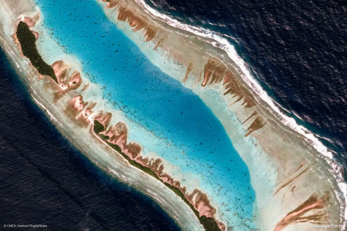
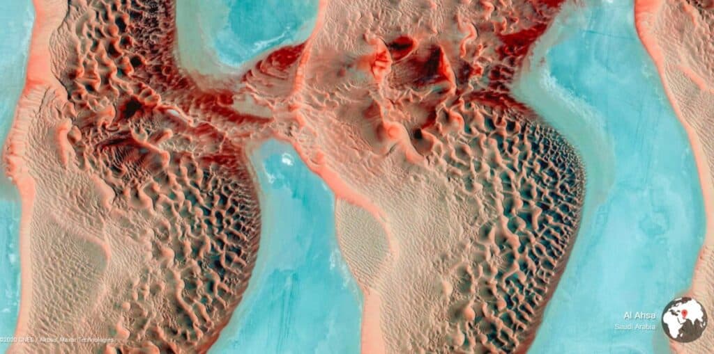
Many of these images have an other worldly quality to them – with amazing colors, textures, and shapes that verge on the abstract. For adding visual interest to your presentations they are hard to beat!
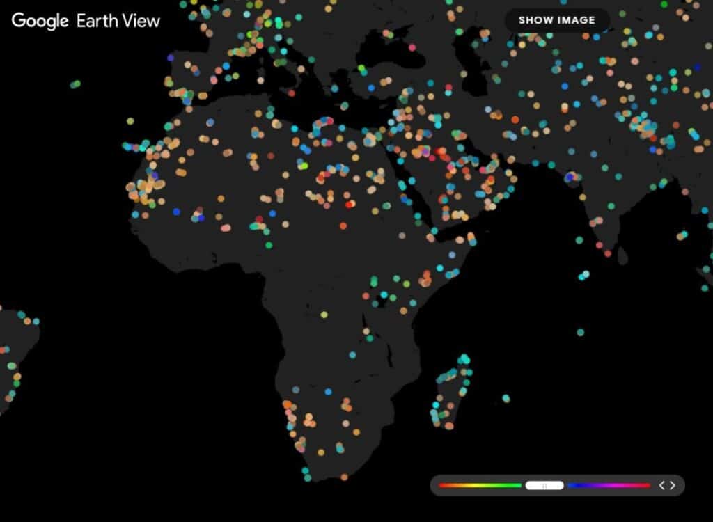
Google Earth View provides an excellent source for stunning images, with over 2,000 images to choose from. Not only do these satellite images make great wallpaper for your computer screen, they can make great full frame slides to use in your presentations!
As you can see there are thousands of locations available throughout the the world, and half the fun is clicking on these dots to see what comes up. Don’t be surprised if you get totally distracted!
Best of luck with producing your own images and videos using these exciting tools to provide geographic context and stunning visuals in your own presentations.
The featured image at the top of this post shows Mili Atoll, Marshall Islands. Credit Google Earth View.